• Home
  • Search
  • Browse Collections
  • My Account
  • About
  • DC Network Digital Commons Network™
Skip to main content
Digital Commons@DePaul DePaul University
  • Home
  • About
  • FAQ
  • My Account

Home > LAS > LAS Departments and Programs > Geography Department > Map of the Month

DePaul Map of the Month
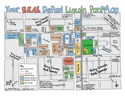
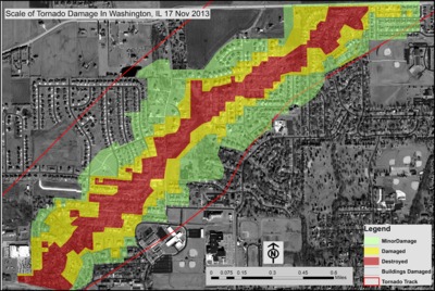
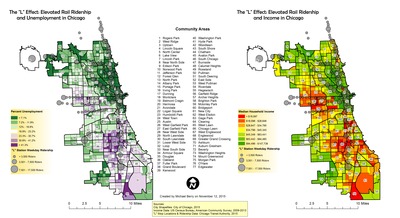
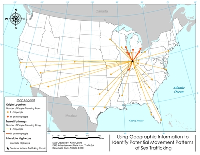
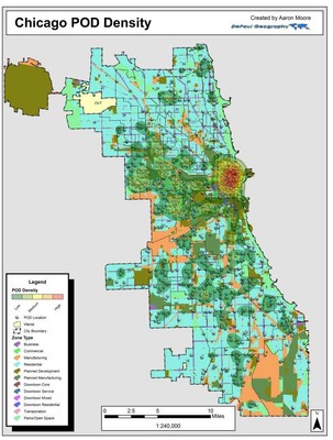
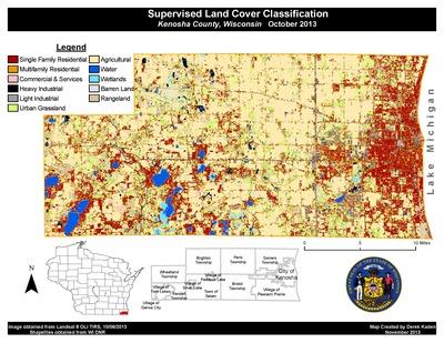
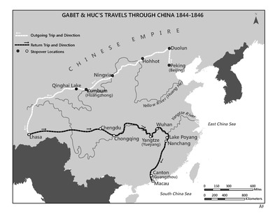
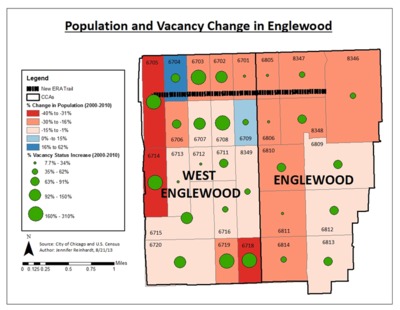
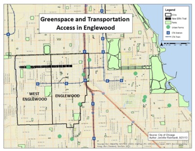
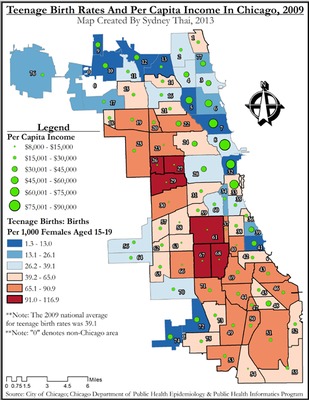
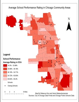
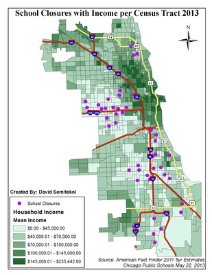
In September 2013, the Department of Geography began its Map of the Month project. On the first of each month in the school year, a map created by a student in one of Geography's Geographic Information Systems classes (GEO 241, 242, 243, 343, 344, 440, 441 and 442) will be posted on Via Sapientiae. These maps cover a range of locations and topics, as befits the cross-disciplinary nature of Geography. For more information, contact geography@depaul.edu
Printing is not supported at the primary Gallery Thumbnail page. Please first navigate to a specific Image before printing.

Follow

Switch View to List View Slideshow
 
  • December 2016: Kuwait Oil Spill, 1991 by Christopher Gomez

    December 2016: Kuwait Oil Spill, 1991

  • November 2016: Ratification of the 19th Amendment by Aidan Schenkus

    November 2016: Ratification of the 19th Amendment

  • October 2016: Your Real DePaul Lincoln Park Map by Brooke Robinson

    October 2016: Your Real DePaul Lincoln Park Map

  • September 2016: Scale of Tornado Damage in Washington, Illinois by Daniel Mehmel

    September 2016: Scale of Tornado Damage in Washington, Illinois

  • June 2016: The “L” Effect: An Examination of Income, Employment & Mass Transit in Chicago by Michael Berry

    June 2016: The “L” Effect: An Examination of Income, Employment & Mass Transit in Chicago

  • May 2016: Using Geographic Information to Identify Potential Movement Patterns of Sex Trafficking by Kelly Collins

    May 2016: Using Geographic Information to Identify Potential Movement Patterns of Sex Trafficking

  • April 2016: Chicago Employment And Poverty in Enterprise Zones 2000-2010 by Alex Costakis

    April 2016: Chicago Employment And Poverty in Enterprise Zones 2000-2010

  • March 2016, Dominant Industries In Rust Belt Cities In 1950 by Corey J. Shupp

    March 2016, Dominant Industries In Rust Belt Cities In 1950

  • February 2016: Distribution of Immigration Attorneys and Notaries in Relation to the Percent of Foreign Born Residents in Chicago By Neighborhood by Cecilia Mendoza

    February 2016: Distribution of Immigration Attorneys and Notaries in Relation to the Percent of Foreign Born Residents in Chicago By Neighborhood

  • October 2015: Green Spaces and Public Health by James Wong

    October 2015: Green Spaces and Public Health

 
  • 1
  • 2
  • 3
  • 4
  • 5
  • 6


Search

Advanced Search
Search Tips

  • Notify me via email or RSS

Login and Notify

  • Register/Login
  • Notify me via email or RSS

About The Commons

  • Home
  • General Information/Policies
  • FAQs
  • University Library Homepage

Links

  • Geography Department Website

Browse

  • Collections
  • Disciplines
  • Authors
  • Subjects

Author Corner

  • Author FAQ
  • Policies

At A Glance

  • Top 10 Downloads of All Time
  • 20 most recent additions
  • Activity by year

Gallery Locations

  • View gallery on map
  • View gallery in Google Earth
 
Elsevier - Digital Commons

Home | About | FAQ | My Account | Accessibility Statement

Privacy Copyright