


Preview
Creation Date
2016-09-08
Description
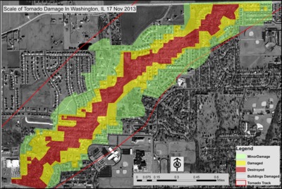
Providing quick damage assessment maps to areas that have been affected by large scale natural disasters enables local state and federal governments to measure the amounts and types of aid needed to assist those affected most by such calamities. On November 17, 2013 an EF4 tornado ripped through the town of Washington, Illinois, causing over 1,000 buildings to sustain damage. Daniel Mehmel completed a poster focusing on this event and property damage for Alec Brownlow's GEO300 - Geographical Inquiry (Senior Capstone) class in Autumn 2015. This map from that poster evaluated damage of building structures after the catastrophic tornado, addressing the type of structures that were affected and gauging the scale to which the building were damaged. With GIS, Daniel mapped out the location of damaged structures, and the scale of damage using the tornado injury scale (TIS) and the Enhanced Fujita scale (EF-scale) of tornado intensity. Using demographic and Tazewell county assessor information he assessed the amount of property damage as well as the reconstruction costs to rebuild properties. He hopes his work can be used by local governments in providing actuarial models for homeowners and insurance companies. Daniel was awarded first place in the Illinois GIS Association's (ILGISA) 2016 undergraduate student symposium competition for this project.
Keywords
tornado, real estate, disaster, climate, GIS