


Preview
Creation Date
2014-02-20
Description
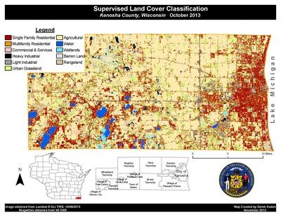
Landsat 8 satellite imagery and GIS were used by Derek Kaden to classify land cover in Kenosha County, Wisconsin, as part of his GEO 243 – Remote Sensing course in Fall 2013. Land cover classification maps have a wide range of uses, some of which include community development; natural resource management; or even damage assessment after natural disasters or wars. Using classification routines he trained the system to recognize eleven land cover types based on the spectral reflectance of the land surface across the visible and infrared spectrum. Derek’s map clearly indicates housing (in red and orange), agricultural land (beige) and park land (green), in Kenosha county.
MapOfMonth_Kaden.pdf (2900 kB)
Keywords
Wisconsin, GIS, Landsat, land use, satellite, Kenosha, USA