


Preview
Creation Date
2014-03-16
Description
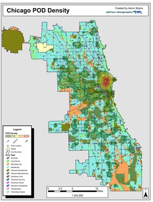
PODs, or Police Observation Devices, are a specific type of closed-circuit television cameras capable of capturing images and tracking individuals that are primarily monitored by the Chicago Police Department. Using a 1,216 point dataset provided by Professor Rijav Shah, University of Illinois-Chicago, DePaul undergraduate Aaron Moore selected PODs based on the zoning type in which the cameras were located. For his Senior Capstone in GEO300: Geographical Inquiry, Aaron created a density layer was then created based on the number of PODs within each zone type. Select structures within these “hot spots” were identified with the use of Google Earth that lie in proximity of the select intersection mentioned In the image captions. The map on the left depicts the total density of PODs throughout Chicago, with the highest concentration occurring Downtown and clusters found to the west and south. The map on the right shows PODs that lie within residential zones were the most widely dispersed of all zone types, with “hot spots” occurring to the west and at the Cabrini row houses on the city’s Near North Side.
Keywords
camera, police, security, surveillance, chicago, neighborhood, crime