


Preview
Creation Date
2014-04-21
Description
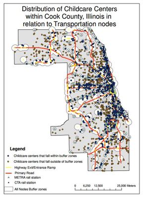
In this map, which displays child care centers in Cook County, buffer zones were determined from the following criteria: a 10 minute walk from the CTA/METRA stations (which equates to about 0.5 mile), or a 1 mile drive from an on/off ramp for a highway/primary road ramp. According to the map, 422.18 sq miles of Cook County lie inside of the transportation buffer zones. Additionally, 53% of all childcare centers are located within the buffer zone areas, indicating measurable clustering is occurring around transport nodes.
Keywords
GIS, child care assistance, Cook County, Chicago