


Preview
Creation Date
2019-05-09
Description
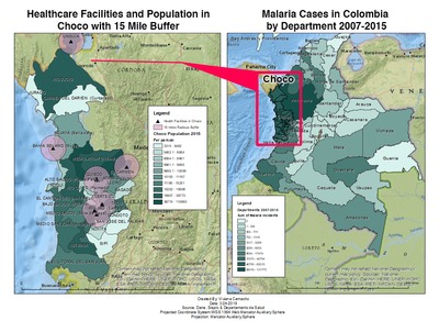
Viviana Camacho completed these maps in Geo 346: GIS Analysis of Environmental and Public Health in Fall of 2018, as part of a project investigating hot-spots of malaria and limitations of healthcare access in Colombia. Viviana found that in the years of 2007-2015, the administrative department of Choco had the highest cases of malaria in Colombia. Using buffer analysis, Viviana identified that a majority of cases were at least 15 miles away from healthcare facilities, contributing to the endemic and repeated cases of cholera. Viviana identified factors of poverty, illegal mining /deforestation and flooding which creates ideal habitat for mosquitoes carrying malaria, and although other departments in Colombia are seeing malaria cases stabilizing or decreasing, cases of malaria in Choco continue to rise. The lack of healthcare services in Choco available to indigenous and afro-columbian populations outside of urban areas is suggested by Viviana to be a large part of the reason that malaria continues to be a serious problem in Choco.
Keywords
Malaria, Colombia, GIS, Public Health