


Preview
Creation Date
2017-01-06
Description
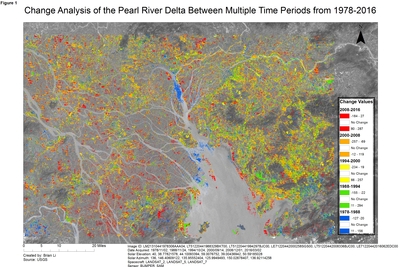
Brian Li completed this change analysis map in GEO 243 - Remote Sensing. In this visualization, Li shows changes to the landscape of the Pearl River Delta from 1978-2016. Six Landsat images of the region from 1978, 1988, 1994, 2000, 2008, and 2016 were used to form the change analysis for each of the five time periods. The base image is the Pearl River Delta in 1978, just before rapid urbanization started in the region. In the analysis each “change image” is derived from a pixel-level subtraction of the older image from the newer. Where there is no change the difference is close to zero, and these pixels are set as transparent. Where there is change (pixels became significantly brighter or darker) a different color is set for each time interval; 1978-88 blue, 1988-94 green, 1994-2000 yellow, 2000-08 orange, and 2008-16 red.
The Pearl River Delta is a region in southern China that contains the world’s largest agglomeration of cities and metropolitan areas by size and population after economic reforms adopted by the Chinese government in the 1978. It was one of the fastest growing regions from 1980 to present day with unprecedented economic growth and rapid urbanization of rural land. From this change analysis image, we can assess that most of the changes to the landscape occurred in the time frame of 1988-2008 and especially on the east of the Pearl River Delta where the city of Shenzhen is located. Shenzhen was a town with a population of less than 100,000 before 1980, and became a city with a population of more than 10 million in 2010.
Keywords
GIS, Remote Sensing, Landsat, Change analysis, China, urbanization