


Preview
Creation Date
2015-07-22
Description
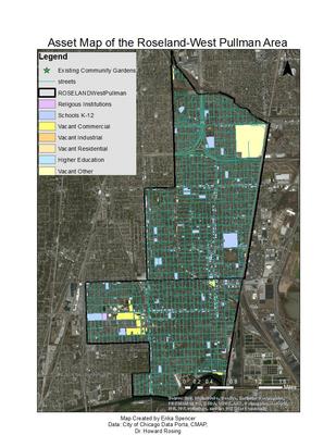
The goal of SEEDs is to provide education and access to fresh produce to the people of Roseland and West Pullman. One way to achieve this goal is through the creation of new community gardens in the area. The success of a garden is directly connected to the individuals who are involved, and gardens attached to groups like schools or churches have greater longevity. In order to determine possible prospective gardens Geographic Information Systems (GIS) was utilized. GIS is a way of displaying data in a spatial format so that it can be useful to individuals. For this project we chose to look at the locations of existing gardens, vacant properties, and community assets such as schools and churches. To achieve this the locations of the vacant residential, commercial, and industrial lots were acquired from the city of chicago, as well the locations of schools and churches in the area. The locations of existing community gardens was procured from previous research done at DePaul University. This data was then all uploaded to ArcGIS online to create a map that could be manipulated by the viewer. The map can be used to identify vacant spaces are idea for a new community garden that are in close proximity to schools or churches. This map can be used as a tool to help SEEDs spread their reach and achieve their goal of providing an educational program that all increases access to fresh food throughout the neighborhood. If enough new gardens are created this network could ideally be connected with food pantries and local farmers markets.
Online map: http://www.arcgis.com/apps/Viewer/index.html?appid=2a0c98bb10354134b9fbfa438a352943
Keywords
community asset, community development