


Preview
Creation Date
2014-03-16
Description
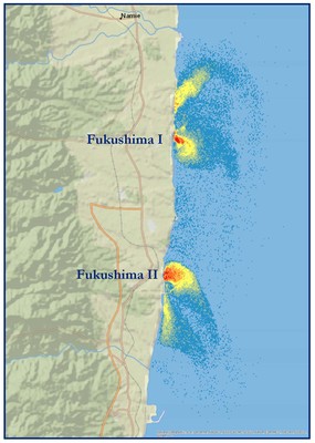
Produced in GEO243: Remote Sensing, this image shows the thermal plumes in the form of hot water being released from Fukushima Daiichi Nuclear Power Plant and Fuk ushima Daini Nuclear Power Plant into the Pacific Ocean (Fukushima I and II respectively). The plants are located in the Futuba district of Fukushima Prefecture, Japan. The image was created using the density slicing technique to manipulate thermal channel 62 of the Landsat 7 data. The data was collected 10 years prior to the devastating Tōhoku earthquake and tsunami that hit the coast of Japan in March, 2011. The analysis is intended to show the facilities during normal operation before the disaster hit.
March 2014_McFadden Fukushima.pdf (24177 kB)
Keywords
Japan, nuclear, thermal plumes, Fukushima, power, ocean