


Preview
Creation Date
2018-09-13
Description
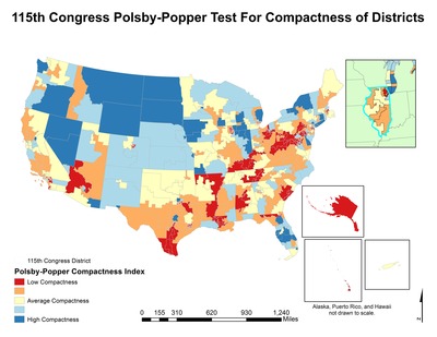
This map was created for GEO 391: Statistical Data Analysis for GIS by undergraduate Dan Scaramelli as part of a project to assess the compactness of districts for the 115th Congress. Compactness is used as a method to determine how gerrymandered, or “rigged” an electoral district is. Districts that have a low measure of compactness generally indicate some degree of political manipulation. Gerrymandering is defined as manipulating the boundaries of an electoral constituency so as to favor one party or class. This means that the state government officials draw districts in one of two ways: the first way breaks up areas where their opponents have a majority (this is called cracking); the second way makes a small amount of districts where the opposition has an advantage but leaves the majority of the rest of the districts in the hands of those drawing the districts (this is called packing). Recent studies into gerrymandering and electoral districts in many states, in addition to coverage in the national media, has increased the number of state legislatures and local organizations considering non-partisan methods of creating electoral districts. In order to understand whether electoral districts for the 115th Congress, Dan used the Polsby-Popper Test to calculate each district’s degree of compactness. The Polsby-Popper test divides the area of a circle with the same perimeter as the district by the square of the perimeter of the district. This test shows districts that have straighter boundaries, such as Wyoming and Nevada, are more compact. Districts that have more convoluted boundaries (such as shorelines, districts in Texas) have a much lower compactness. Compactness was classified on a 0-1 index using the Natural Breaks classification system; 0 - .14 compactness was low compactness, .14 - .42 was below to above average compactness, and .43 - .77 was high compactness. At the end of the project, Dan found that approximately 83% of districts had a Polsby-Popper score that indicated they were not compact.
Keywords
politics, polsby-popper, congress, gis, arcmap, statistics