


Preview
Creation Date
2017-03-31
Description
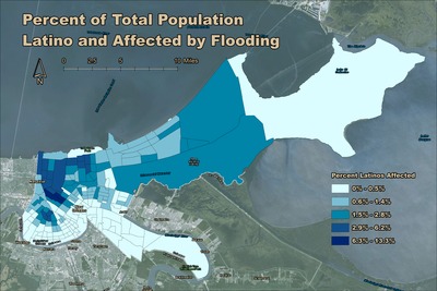
This map was created in GEO 300: Geographical Inquiry in Fall 2016 by Emily Flock and presented at the West Lakes American Association of Geographers conference. Hurricane Katrina ravaged the Gulf Coast in late-August 2005. Catastrophic flooding in New Orleans was well reported. This map uses remotely-sensed satellite imagery along with census data to show which tracts in New Orleans had the highest percentage of Latinos affected by post-Katrina flooding. Just over 2.5% of the New Orleans population affected by flooding was Latino. This contrasts with 41.5% of the flooded population identifying as Black/African American of only one race. The area around Mid-City, New Orleans, was where Latinos were hardest hit by post-Katrina flooding.
Keywords
katrina, population, gis, remote sensing, hurricane, flooding, new orleans, latino