


Preview
Creation Date
2016-06-02
Description
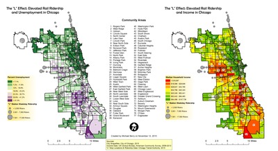
Michael Berry created these maps for the final project of his GEO241 - GIS1 class in Fall, 2015. The goal of the maps created for his project was to effectively visualize and assess the relative usefulness of elevated rail lines of Chicago to citizens of different income levels and labor force demographics. He suggested that there seemed to be a strong positive correlation between low unemployment and high mass transit usage, and a weaker correlation between income levels and mass transit usage. He concluded that it is likely that mass transit users at different socioeconomic levels have different opinions of and reasons for using the “L.”
Keywords
Transit, Rail, Elevated Rail, Commuting, Accessibility, Income, employment, transportation