


Course Website Archive
Files
Download Full Text (33.9 MB)
Description
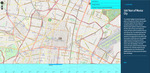
This exhibition highlights the broad development patterns of the great City of Mexico, from its origins as the island capital of the Aztec Empire to its sprawling contemporary contours. Featured elements include significant architectural additions and other urban structures such as plazas and avenues that help to shift the orientation of the city and its life over time. This Neatline map shows how the traditionally West-facing city which was once contained to the original island in the middle of Lake Texococo grows in all directions over time, especially towards the end of the 19th century with the addition of the Paseo de la Reforma connecting the historic center with Chapultepec. In the 20th century, the seismic growth of modernism helped to shift Mexico City's orientation towards the south, with developments such as the University City (UNAM) located in the rocky outrcrop in the southern basin, the pedregal.
Publication Date
Spring 2017
File Type
Primary archival file: Zipped combination of HTML, CSS, JS, PHP files. Can be opened by web browser.
Keywords
mexico city, aztec empire
Disciplines
Archaeological Anthropology | Arts and Humanities | Latin American Languages and Societies | Race, Ethnicity and Post-Colonial Studies | Social and Behavioral Sciences | Urban Studies and Planning
Recommended Citation
Cosentino, Delia, "HAA 375 World Cities: 500 Years of Mexico City" (2017). Course Website Archive. 3.
https://via.library.depaul.edu/course_website_archive/3
Included in
Archaeological Anthropology Commons, Latin American Languages and Societies Commons, Race, Ethnicity and Post-Colonial Studies Commons, Urban Studies and Planning Commons
Comments
To view website, download ZIP file, unzip folder, and open with any standard web browser (Google Chrome, Firefox, Microsoft Edge, etc).