


Preview
Creation Date
2016-04-06
Description
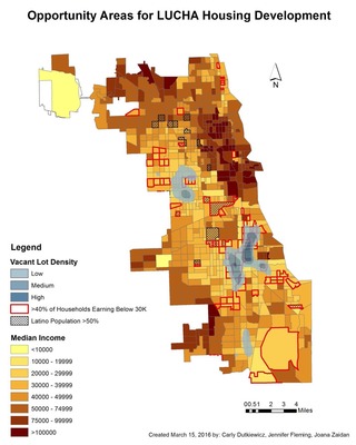
In Chicago, as in many other cities, there continues to be a shortage of affordable housing, and the Latin United Community Housing Association (LUCHA) is one of many organizations whose mission is to help address this problem and offer assistance to citizens in need. This project was commissioned to help LUCHA’s affordable housing development program, under their building development department. They have tasked us with identifying potential lots in the city of Chicago for the construction of affordable housing developments. They are interested to know which other neighborhoods in the city that they haven’t worked with yet, may also be in need of their services. LUCHA works with three primary criteria that guide the choice of the location of their affordable housing developments: space (i.e. lot dimension size, vacancy), income level in the area, and concentration of Latino population. We worked with GIS techniques and the datasets obtained and used in this project include median and household income, Latino population distribution, and city-owned vacant lots. GIS processing tools (including Kernel Density and Point Distance) were used in the analysis to determine where these three criteria overlap. Analysis was conducted at the census tract level. The map above is a city-wide scale map showing income level, Latino population, and vacant lot density.
The final report for this community GIS project can be viewed here.
Keywords
Affordable housing, Chicago