


Preview
Creation Date
2017-04-26
Description
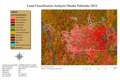
Elena Becerril created this map in Remote Sensing I (GEO 243) in 2016. The map illustrates thirteen land cover classifications throughout Omaha Nebraska. These classifications are produced by unique spectral response patterns collected through training samples. This map was produced by using the training sample manager tool and maximum likelihood classification tool. The data was collected in 2016 and show the amount of urban sprawl within Douglas County.
Keywords
Remote Sensing, Land Cover Classification, Omaha Nebraska