


Preview
Creation Date
2016-12-05
Description
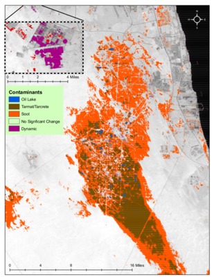
Christopher Gomez completed this map as a final project for Remote Sensing II, GEO 343, in Spring Quarter 2016. This map identifies the distinct types and total geographic extent of oil contamination in a war-torn Kuwaiti oil field. In January 1991, retreating Iraqi forces set fire to the Burgan oil fields as a form of environmental and economic sabotage. 1 year later, after an estimated 600+ oil fires were extinguished and 1 billion barrels of oil burned, a wasteland network of oil lakes, hardened tar, and thick soot draped over the sensitive desert environment. This analysis takes place two years after the first fires were set. While this project constitutes a snapshot, or "retroactive monitoring", of this historic catastrophe, similar satellite imagery processing and analysis methods can be utilized today for critical, proactive disaster management.
Keywords
Oil, kuwait, remote sensing, energy