


Preview
Creation Date
2015-02-25
Description
In June, 2014, the United Nations High Commissioner for Refugees estimated that there were over 50 million people throughout the world that had been forced to flee their homes because of armed conflict, environmental disaster, and other humanitarian emergencies. As these numbers continue to increase, displaced persons are becoming increasingly vulnerable. Resettlement to nations, such as the United States, can provide these individuals the opportunity to continue their lives anew in a safe and peaceful environment.
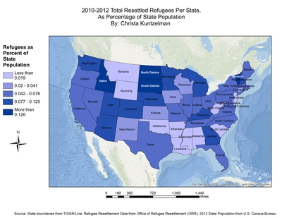
In this map, produced for her GEO441/MPS552 - GIS for Community Development course, Kuntzelman displays current refugee density across the contiguous 48 United States. This density is determined as the total resettled refugees per state as a percentage of overall state population.
Kuntzelman has chosen to represent this data as an integral component of a larger project in which she questions if given the increasing number of global refugees the United States Office of Refugee Resettlement (ORR) could resettle additional individuals from this vulnerable population.
The map may help in correcting prevalent stereotypes that the United States currently resettles large numbers of refugees. Only four states: Idaho, Vermont, and North and South Dakota, have refugee populations that are greater than 0.126% of the population.
Keywords
refugee, density, settlement, population, demographics, immigration, USA