


Preview
Creation Date
2014-10-06
Description
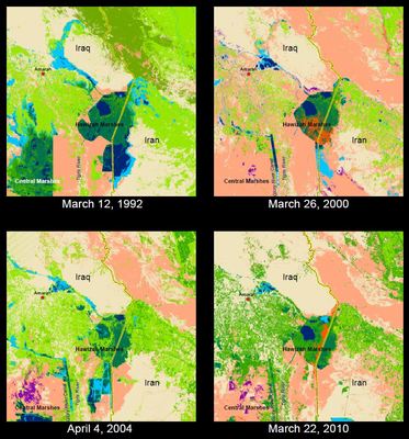
As part of his work in GEO 243 - Remote Sensing, Daniel Memel decided to examine the the Mesopotamian Marshlands located in southern Iraq. An integral part of the Tigris-Euphrates River Basin and once the third-largest wetland in the world, in the 1990s Saddam Hussein started draining Iraq’s Mesopotamian Marsh lands. This reduced the extent of the marshlands as well as displacing thousands of locals whose livelihoods depended on the marshlands. These maps show the radical change of the marshlands over the course of 18 years from 1992 to 2010. By the year 2000 the marshlands were reduced to only one-tenth of their 1973 levels and one fifth of their 1992 levels. After the fall of Saddam Hussein, efforts were made to re-flood the Mesopotamian Marshlands in 2003 to revive a dying ecosystem. Over the next few years the marshlands grew slowly but never to the extent of even the 1992 levels. The Iraqi government has made continuous efforts to maintain the marshlands, however recent droughts as well as overuse from agriculture and infrastructure upstream in the form of dams, dikes and canals have reduced the seasonal flooding that allows the marshlands to flourish.
Keywords
iraq, middle east, water, ecosystem, wetland