


Preview
Creation Date
2014-06-01
Description
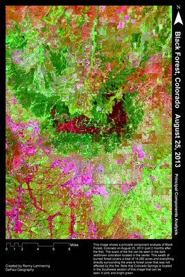
Renny Lammering’s image was generated as part of his coursework in GEO343 – Remote Sensing II. It displays a Principal Component Analysis (PCA) of a Landsat 8 image of the Black Forest Fire area, taken on August 25, 2013, about two months after the fire burned. Black Forest is located near Colorado Springs and is comprised of over 13,000 residents as well as 192,000 acres of Ponderosa Pine forests. Founded as a logging community in the 1850s, Black Forest has since become a residential area and vacation destination for many. As the population of Black Forest began to increase, so too did their concern for seasonal wildfires and the destruction they can cause. On June 11, 2013 a small fire broke out and grew into what would become the most destructive fire the state had ever faced – just one year after the Waldo Canyon Fire. Waldo Canyon was the previous most destructive fire in Colorado history, and it also occurred in the Colorado Springs area. Black Forest Fire lasted for 10 days and burned 14,280 acres, destroyed 486 homes, killed 2 people and caused over $85 million in damage. The reason this fire was so destructive was primarily due to the unusually dry weather and high wind conditions. Additionally, many fire ecologists believe that years of wildfire suppression contributed to the severity of the fire by allowing snags (dead and fallen woody vegetation) to collect which increased its intensity.
Landsat 8 was launched in February 2013 – writing a new chapter in this extraordinary program that has recorded a digital image diary of the planet since 1972. In remote sensing, PCA is used to reduce the redundancy between channels, by creating new image channels (components) – the first three accounting for nearly 100% of the covariance across a stack of multispectral channels ranging through the visible, near infrared, and mid infrared spectral range. This allows the analyst to create a 3-color composite with an astounding amount of information – and in this instance to visualize the effects of Colorado’s devastating 2013 Black Forest fire.
Keywords
remote sensing, landsat, colorado, wildfire, black forest, colorado springs, fire, disaster