


Preview
Creation Date
2014-03-16
Description
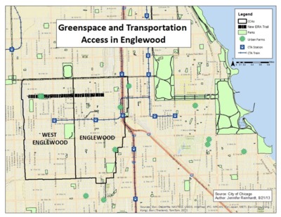
As part of DePaul’s new Master’s degree program in sustainable urban development, Jennifer Reinhardt wished to examine the proposed New ERA (Englewood Re-making America) Trail and Open Space Plan to develop a 2-mile park along an elevated abandoned rail-road track on 59th Street and measure its potential economic, environmental, and equitable impact upon the community. Using cartographic skills and data analysis techniques learned in GEO 441: GIS for Community Development, Reinhardt analyzed variables such as existing transportation infrastructure, access to greenspace, and the change in population density and vacancy status per census tract. The map on the left shows that Englewood has experienced dramatic population loss within the past ten years (up to 40% in some areas) and the census tracts with the highest population decrease also have the greatest vacancy status increase. The map on the right demonstrates that Englewood is very well situated with access to major CTA rail lines, expressways, and freight railways as well as in close proximity to numerous parks and urban farms. Both maps support the New ERA Trail Community Vision Plan claim that the trail will “strengthen the confidence of residents and prospective investors” and suggest that the New ERA Trail is uniquely positioned to re-purpose vacant lots and coordinate community assets to help reverse the negative demographic and socio-economic trends currently experienced in Englewood.
Keywords
Chicago, Englewood, African American, community development, rail, sustainable, urban, parks