


Preview
Creation Date
2014-02-20
Description
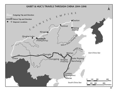
As part of his GEO398: Internship, Aaron Faulkner has transformed narratives from the Vincentian archives into maps. This map was created for the fourth volume of The Vincentians, A General History of the Congregation of the Mission, to be published in 2014. The map shows the 1844-1846 travels of the Vincentian missionaries, Évariste Régis Huc, C.M., and Joseph Gabet through the Chinese Empire, including Inner and Outer Mongolia, Tibet and Portuguese Macau. The outgoing trip, shown in white, took the missionaries to seven stopover sites, traveling across plains, steppes, and eventually the Himalayas. From Lhasa they traveled east following the Yangtze River wherever possible before heading south and terminating their trip in Macau. This cartographic reference was created by studying period maps and extracting key data, in the form of trails, text, and place marking, to create a contemporary rendering with the help of digitization.
Keywords
GIS, China, Vincentian, Mission, 19th Century, Catholic